
School Closing Prediction For Monday 11/10/2025
- Jonah Drake (Owner & Co-Founder)

- Nov 9, 2025
- 4 min read
Updated: Nov 11, 2025
Day 1 School Closing Prediction Results
Forecast Valid: Monday, November 10, 2025
Forecast Issued: Sunday, November 9, 2025, 4:14 PM EST
Forecaster(s): Jonah Drake and Jacob Melton
Forecast Results Published: Monday, November 9, 2025, 3:05 PM EDT
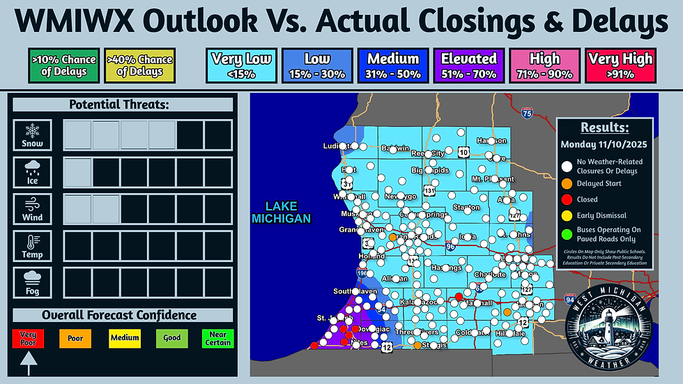
Transparency; that's a huge part of our snow day predictions this year - check out our results from our prediction that we posted last night for today. Several school closings were reported today in the area we highlighted was at the greatest risk (Berrien County) for closures in last night's school closing outlook. A couple of other isolated closures and delays were reported elsewhere in the area.
More closings & delays possible for Tuesday morning with additional heavy lake-effect snow expected across parts of the area - we'll have our prediction on that out shortly.
Day 1 School Closing Prediction
Forecast Valid: Monday, November 10, 2025
Forecast Issued: Sunday, November 9, 2025, 4:14 PM EST
Forecaster(s): Jonah Drake and Jacob Melton

Special early access is rewarded to our Community Supporters! Join a plan for as low $1.99 per month and help us on our mission to serve all of you and provide crucial, life-saving weather information, live storm chasing, and snow day predictions!
Check back on our social media pages linked at the top menu of this page later this evening if you can't support us for our full forecast! We will release this forecast in full to everyone at 7:00 PM EST.
Summary: Areas of heavy lake-effect snow are forecasted to impact parts of Michigan this evening and into the overnight hours. This snow accumulation may result in some school delays and closures across the area on Monday morning.
Discussion:
As aforementioned, areas of heavy lake-effect snowfall have been ongoing throughout the day today, and are forecast to continue at times through the remainder of the day and into the overnight hours. Strong winds with gusts of 20-40 MPH, and the potential for liquid snow melt and rain from the daytime hours today to re-freeze as ice and black ice overnight as temperatures drop into the 20s and teens, are also concerning for school closure/delay potential for Monday morning.
The combination of these threats would normally result in a higher-end outlook being needed to address these concerns for closures/delays, especially given the early-season nature of this particular event. However, this is a classic and difficult lake-effect forecast with very poor confidence in any one specific area seeing significant accumulations, as even the most minor shifts of wind direction can make major differences in final totals. Therefore, given the aforementioned low forecast confidence, we have opted to be extremely conservative with this forecast, and that will be noted throughout.
Snow Threat Index (4/6):
Our "Threat Index" for snow is at a level 4/6 for this event and is obviously the leading threat index given the amounts and nature of the snowfall that is being forecasted. Particularly in far Southwestern Lower Michigan, total snow accumulations of 5-8 inches, with locally higher amounts, are forecasted and this snow is certainly heavy and wet in nature - not only, will these amounts create hazardous travel conditions in of themselves, but the heavy/wet nature of the snow will have the potential to bring down tress and powerlines which will only further increase the threat for some scattered to widespread school closures/delays in whatever areas see the most persistent and heaviest snow bands. Current thinking is that the central parts of Berrien County and into far Southwest Van Buren County have the best chances for seeing these bands of snow.
Elsewhere, we are not anticipating that final snowfall amounts will be of much significance, with the exception of 2 other notable areas; the first being Northwest Mason County, and the second being far Southeast Gratiot County into Northeast Clinton County. In these areas, snow accumulations of 1-5 inches are possible, but the timing of the snowfall in these areas is not particularly conducive to prompting school closures or delays. For Mason County, we expect that the heaviest snowfall will hold off until after the morning school commute; however, snow may cause some problems for the afternoon commute, which may prompt some early dismissals or a low-end preemptive type school closure. For Gratiot and Clinton Counties, snowfall may not be relevant at all to the school commutes, but given that this is lake effect and difficult to predict, we have opted to keep chances slightly higher in these areas, given the combination of the possibility for additional snowfall and the other threats that will be discussed in more detail in the subsequent paragraph.
Ice Threat Index (1/6) & Wind Threat Index (2/6):
In addition to the snowfall, there is some concern for what we refer to as "re-freezing" or "flash freezing" - a process where liquid snow melt, or even rain, refreezes into ice as temperatures fall overnight, - resulting in the formation of ice and/or black ice. While this is not a forecast that deals with freezing rain or sleet, this type of ice formation is included in the "Ice Threat Index".
Temperatures this afternoon will climb above freezing, particularly near the immediate lakeshore. This will allow the opportunity for rain and snowmelt to remain in its liquid form across parts of the area. Temperatures tonight are forecast to fall into the 20s and even the teens near the US-10 corridor. This will be plenty cold enough to support the risk of this liquid water freezing and creating patchy areas of ice and/or black ice, especially on secondary roads and in rural areas. This may be realized across our entire area, hence the inclusion of "Very Low (<15%) probabilities across our entire forecast area.
Additionally, there are some minor threats stemming from the wind as well; once again, this is mostly concerning parts of far Southwest Michigan. Winds may gust to around 20-30 MPH, with some gusts reaching as high as 40 MPH during the evening and overnight hours. This will have a 2-fold impact on this forecast; first, these winds will support scattered areas of blowing snow and reduced visibility, especially in open areas. Two, these winds will further support the damage to trees and power lines, which could lead to some isolated or even scattered power outages, which may force schools to close regardless of road conditions.
Graphical Forecast:


Comments