
School Closing Outlooks For Wednesday 01/21/2026, Thursday 01/22/2026, and Friday 01/23/2026
- Jacob Melton

- Jan 20
- 4 min read
Updated: Jan 21
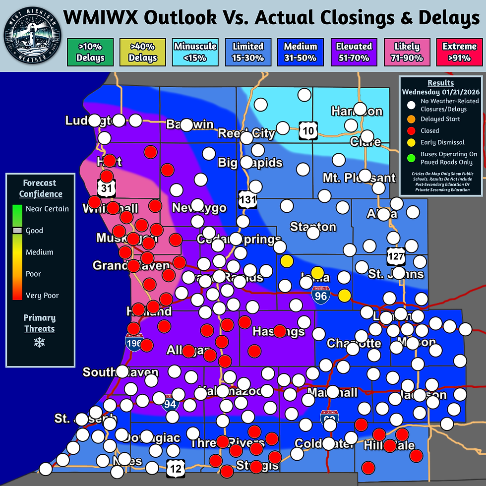
Day 1 School Closing Outlook Results
Forecast Results Issued: Wednesday, January 21, 2026, 12:53 PM EST
Here are the results for our school closing outlook from yesterday evening for today. The majority of school closures this morning were generally along the lakeshore between Holland and Hart, as we generally expected with the placement of the “Likely” probability zone. Some closures were also reported south of Grand Rapids in Allegan and Barry counties, with additional pockets of closures in St. Joseph and Hillsdale counties.
While most schools remained open elsewhere, Belding, Ionia, and Portland schools in Ionia County have announced early dismissals due to the weather conditions.
Day 1 School Closing Outlook
Forecast Valid: Wednesday, January 21, 2026
Forecast Issued: Tuesday, January 20, 2026, 4:45 PM
Forecasters: Jacob Melton & Jonah Drake

Summary:
School closures are likely across portions of West Michigan, particularly near the Lakeshore, on Wednesday morning, as another round of locally heavy snow will be in the area.
Discussion:
School closures are looking likely once again on Wednesday morning, particularly near the lakeshore north of Holland, as another round of locally heavy snowfall will set its sights on our region into Wednesday morning.
Winter Storm Warnings and Winter Weather Advisories go into effect starting at Midnight across much of West Michigan, except for Osceola and Clare counties.


The heaviest snowfall will be in the Winter Storm Warning area due to lake enhancement, with total snow accumulations of 3 to 8 inches. Localized heavier amounts, between 9 and 12 inches, are possible. Snowfall rates up to 1” per hour are possible in these areas as well, which may complicate any road-clearing efforts during the morning commute. This is where we have the “Likely” zone for school closure or delay potential, generally along the lakeshore between Holland and Hart.

In the winter weather advisory area, total snow accumulations are generally going to be slightly on the lower end, between 2 and 6 inches. The exception to this is south of Grand Rapids, between the I-96 and I-94 corridor, where local amounts that may be slightly higher are possible. This area is also showing elevated 1-hour snowfall rates as well, with up to ¾ inch per hour snowfall rates a possibility. This is where we generally have the “Elevated” and “Medium” risk zones.
Along the US-12 corridor, along with areas north of I-96 and east of US-131, snowfall totals and rates drop off, which may tend to make school closures and/or delays less likely. However, we have opted to maintain “Minuscule” and “ Limited” probabilities.
Graphical Forecast:

Day 2 School Closing Outlook
Forecast Valid: Thursday, January 22, 2026
Forecast Issued: Tuesday, January 20, 2026, 4:17 PM EST
Forecasters: Jacob Melton & Jonah Drake
Want to read more?
Subscribe to westmichiganweather.net to keep reading this exclusive post.


