SPC Adds Low-End Severe Weather Threat For West Michigan Tomorrow
- Jonah Drake (Owner & Co-Founder)

- May 1, 2024
- 1 min read
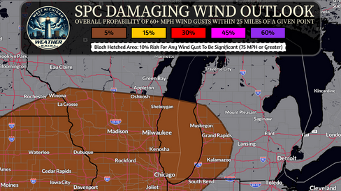
The NWS Storm Prediction Center has introduced low-end probabilities for severe weather across West Michigan tomorrow. Both confidence and severity of potential severe weather are responsible for precluding higher risk levels with this severe weather threat. If severe weather does occur the threats will be for damaging wind gusts of 40 MPH to perhaps as high as 60 MPH and some small to large hail. The risk for tornadoes with this threat appears negligible (less than 2%).
Morning rain showers will delay the ability for daytime heating to destabilize the atmosphere ahead of afternoon/evening convection and the risk for thunderstorms - and associated severe weather threat - will be highly dependent on the impact that morning convection has on the degree of daytime heating that can occur tomorrow.
One caveat that may lead to a corridor of higher severe potential somewhere in the Great Lakes region is that morning convection may move out of the area faster than current computer weather model guidance is suggesting which would allow for less inhibition on the ability for daytime heating and subsequent destabalization that occurs.
In addition to the severe weather threat, a low-end risk for flash flooding caused by rainfall will exist across far western lower Michigan tomorrow. The Weather Prediction Center has highlighted some lakeshore areas with a level 1/4 Marginal Risk for Excessive Rainfall.

We'll continue to monitor and will provide updates as needed.


Comments