


Tomorrow's West Michigan Severe Weather Risk Upgraded
- Jonah Drake (Owner & Co-Founder)

- Jun 12, 2024
- 2 min read


Summary:
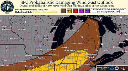
Bottom line up front: Computer weather model guidance is now suggesting that a more favorable environment for severe thunderstorms will be in place tomorrow afternoon and evening than was previously realized. Because of this, the NWS Storm Prediction Center has upgraded portions of southern lower Michigan to a Slight Risk (level 2/5) for severe weather tomorrow.


Discussion:
As aforementioned, a more favorable environment for severe weather than was previously forecasted will likely be in place across parts of Western Lower Michigan tomorrow afternoon and evening.
This more favorable environment will likely be supportive of all severe weather hazards, with the most likely threats being small to large hail up to 1.50 inches in diameter and damaging wind gusts of 60-70 MPH. An isolated tornado or two can also not be ruled out, especially in areas that experience any localized interactions with lake breezes from Lake Michigan.
Through the day tomorrow strong warm air flow will bring hot, moist, unstable air into much of the region and will push high temperatures into the upper 80s and into the mid 90's especially across parts of southern lower Michigan along and south of the I-94 corridor. It will be very humid with dew points well into the low to mid 60's as well and daytime heating will push the CAPE - Convective Available Potential Energy (storm juice) well into ranges that will be favorable for the development and longevity of strong to severe storms. In addition to the favorable air mass, we will also have a favorable wind profile for both damaging wind gusts and an isolated tornado as the system brings upwards of 40-50 knots (~60 MPH) of flow through the region.
Storms will fire across Lake Michigan across parts of the Midwest and Great Lakes region and are currently forecasted to move South/Southeast towards West Michigan as early as 3:00 PM tomorrow. More likely, however, these storms will reach our area sometime after 5:00 or 6:00 PM and will continue to track Southeast through the evening.
There are a few caveats to this severe weather potential, as there often are. In the weather community, we refer to these caveats as "Bust Factors." Tomorrow's "Bust Factors" include the likelihood of isolated to widely scattered morning/daytime rain showers and thunderstorms that will act to inhibit the ability for the atmosphere to warm and destabilize by undercutting sunshine and eating into the CAPE (storm juice) profiles. In addition, inversions (referred to as the "CAP"), even those that are localized in nature, will likely be present for portions of the day tomorrow and questions remain as to whether or not there will be enough forcing to erode those CAP's and allow storms to fire - the fact that storms will likely already be underway will help eliminate this concern, but not entirely.
We'll continue to provide updates as additional details come into better view. Stay tuned!


Comments