
School Closing Outlook For Friday 01/16/2026
- Jonah Drake (Owner & Co-Founder)

- Jan 15
- 2 min read
Updated: Jan 17
Day 1 School Closing Outlook Results
Forecast Results Issued: Saturday, January 17, 2026, 1:35 PM EST
Here is the list of closings, delays, and early dismissals we are able to confirm from Friday. Please see the discussion below to understand more details.

Day 1 School Closing Outlook
Forecast Valid: Friday, January 16, 2026
Forecast Issued: Thursday, January 15, 2026, 12:38 PM EST
Forecasters: Jonah Drake

Summary:
There is a “Medium” risk of school closures, early dismissals, and/or delays on Friday due to lingering impacts of very heavy lake-effect snowfall last night and today in Berrien County, as well as additional lake-enhanced snowfall expected overnight tonight and on Friday.
Discussion:
Another tricky forecast is on the table with regard to Friday morning school closing potential.
We have two main forecast components to consider. Lingering road conditions across Berrien County and the additional accumulating lake-enhanced snow that is expected from late tonight through Friday evening.
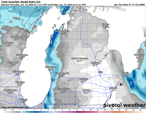
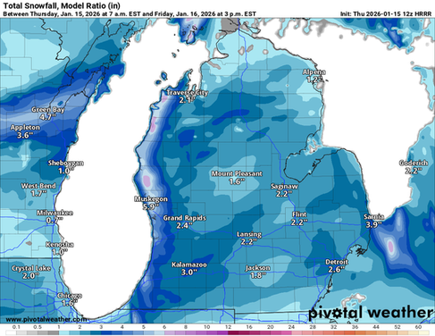
We will start with the latter of the two first. Bottom line up front is that a solid 1-4 inches is expected for most of our area west of US-131, especially along the immediate lakeshore areas north of I-94. Normally, totals this low would only support a maximum risk of “Limited,” however, we have opted to introduce “Medium” probabilities because current guidance suggests that snow will continue throughout the day on Friday in these areas, supporting totals of 2-6 inches with locally higher amounts by the time the Friday afternoon commute would be getting started.


Where this gets tricky is that school administrators don’t normally cancel school if there are no ongoing impacts to the morning commute. So we feel that school closings and delays aren’t really a significant threat at this point, as snow piles up; however, we definitely see the potential for districts to release students and staff early tomorrow. This will be tough for us to verify, however, as many districts do not communicate when they do so, and many already have scheduled early dismissals due to it being the end of the semester and final exams.
The other forecast consideration that must be given pertains mainly to far Southwest Michigan in Berrien County, where more than a foot of snow has already fallen since yesterday afternoon.
While snow will be tapering off in that area, a few additional inches are quite possible this afternoon and overnight. Regardless, it certainly takes a decent chunk of time for crews to clear roads, especially secondary roadways, after a storm of this magnitude, so we would not be surprised to see some districts in this area remain closed on Friday due to lingering treacherous roadways.
Graphical Forecast:

Additional school closings are likely early next week due to dangerously cold wind chills. Make sure you're following on social media or signed up for email alerts on our website for future outlooks!


Comments