
Update On Severe Weather & Flooding Concerns For This Week
- Jonah Drake (Owner & Co-Founder)

- Jul 30, 2024
- 3 min read
Summary: The forecast for this week remains largely the same with a few small changes. Overall, warm and humid weather continues.
Day 1 - Today (Tuesday 07/30/2024):


The first change to this week's forecast concerns the weather today. Overall, the weather today is trending to be rather pleasant... heat and humidity aside.
As expected, some isolated rain showers are ongoing this morning. These should clear out as we approach the mid to late morning hours and will give way to mostly sunny skies through much of the day today.
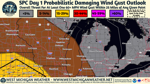
While we can't entirely rule out an isolated shower or thunderstorm developing this afternoon the chances for this are low. Similarly, chances are low for thunderstorms overnight. Computer weather models are struggling with whether or not the ongoing line of showers and thunderstorms will make it into West Michigan later this evening into Wednesday. Should any storms make it to West Michigan tonight they could become locally strong to severe posing a threat for an isolated damaging wind gust or two possible. Again, chances for this are low at this time. Storm Prediction Center Day 1 Marginal Risk (shown above) accounts for this with a 5-14% risk for damaging wind gusts to 60 MPH.
With regards to the lowering chances for isolated shower and thunderstorm activity today, the WPC has dropped the Excessive Rainfall risk for today across the region. Given the very humid airmass, any rain showers or storms that do develop could pose a brief heavy rainfall threat but overall totals across a given area should not amount to much that would give cause for flooding concerns.
Day 2 - Tomorrow (Wednesday 07/31/2024):


The weather story for Wednesday is becoming a bit more clear as compared to yesterday's forecast.
Warm and humid weather will continue to dominate the area and will hence prime an environment favorable for a severe weather threat and a heavy rainfall/flooding threat. That said, we will be lacking any real mechanism that could serve to spark the development of any appreciable shower or thunderstorm activity so chances remain rather low.
That said, can't rule out isolated to widely scattered shower or thunderstorm during the afternoon and into the evening hours, especially along and to the East of the US-131 corridor and South of the I-96 corridor.
SPC and WPC Marginal Risks depicted above account for the low, but non-zero, severe weather and flooding threats across the area.
Day 3 - Thursday (08/01/2024):


A stronger forcing mechanism, that could serve to act as a spark for shower and thunderstorm development, is expected to move through the Great Lakes region sometime during the Late Thursday to Late Friday timeframe. Current model guidance suggests an overall faster/stronger evolution of the forcing mechanism. The caveat to that faster/stronger behavior is that it displaces this feature further to South of West Michigan. Having said that, confidence in any thunderstorm activity, and any associated severe weather/heavy rainfall/flooding threat, remains low given that the best chances for thunderstorms appear to remain to the south of the MI/IN/OH state line.
We'll continue to monitor this for any Northerly shifts and the SPC Marginal Risk accounts for this.
Day 4 - Friday (08/02/2024):

Friday will be dependent on the timing of the aforementioned activity that is favored for Thursday evening so will hold off on any specific details surrounding Friday's forecast for the time being.
No SPC Severe Outlook in place but WPC does have a Marginal Risk for Excessive Rainfall in place for the Southeastern portion of our area.


Comments