
Valid 01/23/2024
- Jonah Drake (Owner & Co-Founder)

- Jan 21, 2024
- 2 min read
Issued 7:28pm EST 01/21/2024
An impactful winter system is expected for the Monday evening, and especially, the Tuesday morning commutes. Isolated to widely scattered school closures are possible.
The primary focus is on the areas south of the I-96 corridor, and more so along and south of the I-94 corridor. In these areas, we are expecting a wide range of mixed precipitation in the form of rain, snow, and primarily freezing rain.
Any time we have a threat of freezing rain the obvious concern is that of ice accumulation potential along with any wind that may accompany said ice accumulation. Fortunately, this does not appear to be an Ice Storm at this time and we will likely not see any significant ice accumulations or accompanying winds.
That said, there is the potential for minor to perhaps moderate ice accumulations to occur, perhaps as high as two-tenths (2/10) of an inch.
Regardless of "Ice Storm" criteria, any amount of freezing rain can make for very slick roads, especially given the very cold road temperatures that exist across our coverage area given the long stretch of bitter cold we have experienced recently.
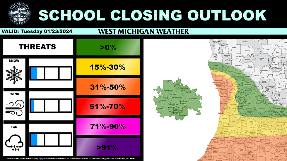
With icy roads in mind we have opted to lead this outlook with an orange-shaded "Elevated Risk" (31%-50% chance) of school closures for areas along and south of the I-94 corridor. North of I-94 there is a broad yellow-shaded "Minuscule Risk" (15%-30% chance) of closures and north of a Hopkins to Holt line there is a green-shaded "Predictability Too Low" (<14% chance) area being highlighted.
The aforementioned Minuscule Risk and Predictability Too Low regions are briefly interrupted by a second, smaller Elevated Risk delineation extending from near Saugatuck to near Ravenna to near Whitehall. This risk area is to account for some generalized computer weather model agreement indicating that 1 to perhaps 3 inches of snow may fall in this region overnight on Monday and would make for slick, snow-covered roads and minor to moderate travel impacts for the Tuesday morning commute which may also cause some isolated to widely scattered school closings in that region as well.
We do expect the bulk of the snow and mixed precipitation, as well as the timing of this system, to change some as the system draws nearer, and subsequently, we expect some changes to our prediction will be necessary, including the possibility for higher risk delineations. We'll reflect these changes in future discussions and School Closing Predictions.


Comments