


School Closing Outlooks For Wednesday 12/10/2025 and Thursday 12/11/2025
- Jonah Drake (Owner & Co-Founder)

- Dec 9, 2025
- 3 min read
Updated: Dec 10, 2025
Day 1 School Closing Outlook Results:
Forecast Valid: Wednesday, December 10, 2025
Forecast Issued: Tuesday, December 9, 2025, 3:52 PM EST Forecast Results Issued: Wednesday, December 10, 2025, 9:35 AM EST
Forecasters: Jonah Drake and Jacob Melton
Summary of Results:
Very poor secondary roadway conditions and much more icy/slushy than expected main roads resulted in a LOT more school closings than we anticipated this morning, especially South of I-96.
Realistically, this outlook could have been verified as a "Likely," or even an "Extreme" risk level for much of the area, which, at the time of its creation, the forecast, and especially the lack of confidence in said forecast, totally limited our ability to nail this down accurately.
This is one of those times when we were technically wrong, but everyone is happy because they get a snow day, so for us, it's a win-win.

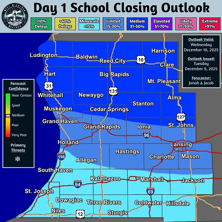
Day 1 School Closing Outlook
Forecast Valid: Wednesday, December 10, 2025
Forecast Issued: Tuesday, December 9, 2025, 3:52 PM EST
Forecasters: Jonah Drake and Jacob Melton

Summary:
There is a “Medium” risk of school closures or delays on Wednesday. The best chance for closings will be North of I-96, where the highest snow totals are expected.
Discussion:
Our second of many winter-weather events this week will likely result in more school closures or delays than we saw on Tuesday morning.
Snow and mixed precipitation are expected across the area, but confidence in the highest impacts is restricted to areas north of I-96, and especially north of M-46. Within this region, snow accumulations from overnight Tuesday into Wednesday morning will likely range from 2-6 inches, with locally higher amounts, and hourly snowfall rates will likely exceed ½ inch per hour.

Between I-96 and M-46, the other thing we need to consider is the possibility of snow mixing with freezing drizzle for a period of time. While any ice accumulations would be minor, this may still result in a few additional problems for the morning commute.
South of I-96, and especially closer to the I-94 corridor, snow will likely mix with, or entirely change over to, rain at times, and this will likely promote some melting. Temperatures in this region are also likely to warm above freezing for several hours, so this will make conditions for rapid snow melting even more than normal for this time of year. For these reasons, confidence in school closures or delays is considerably lower, and we have only opted for “Limited” probabilities or less in these areas as a result.
The one caveat to this risk area is that surface wind gusts up to 40 MPH could result in a couple of particularly isolated power outages, which could in turn result in a closing or 2.
Graphical Forecast:
Day 2 School Closing Outlook
Want to read more?
Subscribe to westmichiganweather.net to keep reading this exclusive post.


