
School Closing Prediction for Wednesday 11/12/2025
- Jacob Melton

- Nov 11, 2025
- 3 min read
Updated: Nov 14, 2025
Day 1 School Closing Prediction Results
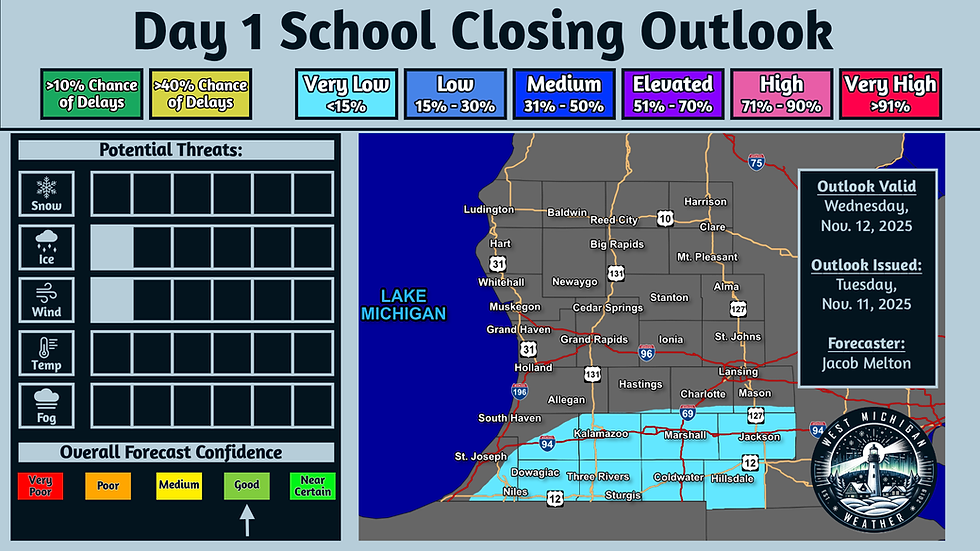
Forecast Valid: Wednesday, November 12, 2025
Forecast Issued: Tuesday, November 11, 2025, 7:10 PM EST
Forecaster: Jacob Melton
Forecast Results Published: Thursday, November 13, 2025, 3:40 PM EST
No school closures or delays were reported across our area on Wednesday. This is consistent with our "Very Low" outlook that we reserve for events that will rarely actually yield any closings or delays but the potential is not completely zero.

Day 1 School Closing Prediction
www.WestMichiganWeather.net/closings
Forecast Valid: Wednesday, November 12, 2025
Forecast Issued: Tuesday, November 11, 2025, 7:10 PM EST
Forecaster: Jacob Melton

Summary:
Some potential exists for slippery roadways Wednesday morning, which may result in a very low chance of a couple of school closings/delays for southern portions of the area.
Discussion:
As mentioned above, a very-low potential for a couple of school closings and/or delays does exist for Wednesday morning mainly across southern portions of our forecast area. Temperatures dropping below freezing for at least parts of tonight will allow for some refreezing of liquid from melting snow from our recent snow event, resulting in the potential for ice and black ice formation. Winds are also elevated resulting in the potential for blowing/drifting snow across roadways, which could also contribute to slippery conditions.
There are a couple factors that is limiting potential for school closings/delays tomorrow morning, including rising temperatures overnight, which has prompted us to keep probabilities on the very low-end of the scale. These factors are discussed further in the individual Ice "Threat Index" discussion below.
Ice Threat Index (1/6):
One of two contributors to the potential of school delays/closings for Wednesday morning is the Ice "Threat Index". While not expected to be as cold as the last couple of nights, temperatures tonight are still expected to fall at or below freezing especially away from the Lake Michigan shoreline, which will contribute to the potential for refreezing of liquid from snowmelt on area roadways. The greatest concern for this will be near and south of I-96, and especially towards the state line, where the National Weather Service office in Northern Indiana put out a statement earlier this afternoon highlighting this potential. With lows in the upper 20s to lower 30s, road treatments will be effective in keeping ice at bay, which is keeping overall probabilities on the low-end.
The other factor keeping overall probabilities lower, is that model guidance is showing temperatures rising above freezing overnight from north to south across much of the area. This will help mitigate impacts from any refreezing that does take place before the morning school commute. For this reason, we have opted to go with very low probabilities near and south of I-94 away from the lakeshore to cover this potential. Some discussion was given to placing low probabilities near the state line, but some residual uncertainty regarding the exact timing of temperatures rising above freezing overnight precluded us from doing so. One thing to keep in mind is that even when temperatures do rise above freezing, rural unpaved roads may remain frozen longer than the paved roads, which are also more likely to receive road treatment measures. This may result in some schools making the decision to operate buses on paved roads only, if not delay and/or close for the day.
Wind Threat Index (1/6):
The other contributor to the very low-end potential of school closings/delays for Wednesday morning is the Wind "Threat Index". Winds tonight will generally be out of the west at around 10-15 MPH, with gusts up to 25-30 MPH possible. This is likely to contribute to isolated areas of blowing snow, primarily in open areas. This is especially a concern in areas that have seen more of the way of accumulation which has not melted already. Not only would this contribute to potential areas of reduced visibility, it will also contribute to slippery conditions on in spots as well.
Graphical Forecast:


Comments